NORWOOD HISTORICAL SOCIETY
[HOME] [SOCIETY] [PEOPLE] [COMPANIES] [BUILDINGS] [STREETS]
[TRANSPORTATION] [BOOKS] [CLIPPINGS] [DATES] [GOVERNMENT] [ODDS & ENDS]
[RESEARCHING YOUR HOUSE] [SUBDIVISIONS]

J. W. & W. C. Baker Addition to Sharpsburg
Town 4 / Fractional Range 2 / Section 34
(* indicates a link to the Hamilton County Recorder's website)
(** indicates a link to familysearch.org - cite using this:
"Ohio, Hamilton County Records, 1791-1994." Images. FamilySearch. http://FamilySearch.org : accessed 2014.)


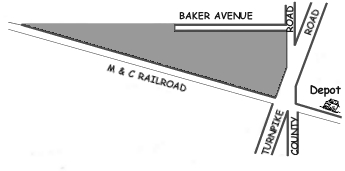
J. W. & W. C. BAKER ADDITION TO SHARSPBURG [Plat Book 3 / Page 68]*
    The streets in or adjacent to this subdivision are:
  • Baker Street
  • County Road (Carthage Avenue)
  • Turnpike Road (Montgomery Road)
    Plat document information:
  • There were 7 lots in the subdivision
  • November 18, 1868: Owners signed document for subdivision and dedicating 20 ft. wide Baker Street for public use
  • November 28, 1868: Plat document received and recorded by Hamilton County Recorder
  • November 30, 1868: Notorized by Francis Cist
Owners: J. W. Baker and W. C. Baker

Interesting Facts:
Notice the "Depot" to the right (east) of the street intersection. This was the original Sharpsburg train station for the Marietta and Cincinnati Railroad. Later, it was replaced with the Norwood Station to the west at the end of Station Avenue on the south side of the tracks and the East Norwood Station on the north side of the tracks at the end of Pine Street near Harris and Forest Avenues.

DEED & MORTGAGE INDEX

The following Deed/Mortgage Index Books contain the pages for lists of real estate transactions. For each transaction will be the names of the Grantors & Grantees (Sellers and Buyers), Mortgagors & Mortgagees and the corrsponding Deed Book and page numbers. Using that information, the deed record for that transaction can be found.

    8th Series Index Book/Page:
    7th Series Index Book/Page (1927-38):
      Deed Index:
    • Lots 1-7 (1927-1931): 72/260**
    • Lots 1-7 (1931-1938): 72/262**
    • BLANK: 72/264**
      Mortgage Index:
    • Lots 1-7 (1927-1931): 72/261**
    • Lots 1-7 (1931-1938): 72/263**
    • BLANK: 72/265**
    6th Series Index Book/Page (1918-27):
      Deed Index:
    • Lots 1-7 (19??-24): 16/302**
    • Lots 1-7 (1924-26): 16/448**
      Mortgage Index:
    • Lots 1-7 (1922-24): 16/303**
    • Lots 1-7 (1924-26): 16/449**


No listings for this subdivision in Series 1-5
(Does this mean there were no real estate transactions
in this subdivision from 1868 to 1918 or later?)


[HOME] [SOCIETY] [PEOPLE] [COMPANIES] [BUILDINGS] [STREETS]
[TRANSPORTATION] [BOOKS] [CLIPPINGS] [DATES] [GOVERNMENT] [ODDS & ENDS]
[RESEARCHING YOUR HOUSE] [SUBDIVISIONS]